Windhoek-Kalahari Route Travel Guide
Embark on a fascinating journey from Windhoek to the Kalahari, passing through landscapes ranging from rolling hills to the vast red dunes of the desert. Along the way, discover the region’s rich biodiversity, with its unique wildlife and stunning starry skies. This route is perfect for those looking to connect with the wild essence of Namibia and enjoy the serenity of the desert. The distance between Windhoek and the Kalahari Desert varies depending on the specific destination within the Kalahari. For example, the drive from Windhoek to the Kalahari Anib Campsite in the Hardap Region is approximately 280 kilometers, which implies a car travel time of around 3 hours. Travel Guide for the Windhoek – Kalahari Route: a true adventure.
Windhoek – Kalahari Tour Guide
An interactive tour guide offers an enriching and dynamic experience, combining detailed information with modern technology.
Our Iceland Travel App allows users to access maps, images, and real-time data, adapting to their preferences and pace.
Interacting with the digital platform allows you to discover historical details, anecdotes, and unique recommendations, making each tour more immersive. Furthermore, its ability to offer multimedia content enhances the understanding and enjoyment of each point of interest, without the need to follow strict schedules or rely on a physical guide.
Windhoek – Kalahari Route Audio Guide
Our self-guided audio tour offers complete flexibility and convenience to explore at your own pace. You can pause, rewind, or replay information whenever you need, allowing you to enjoy the tour without the pressure of a schedule or group. It also provides access to historical facts and interesting facts at any time of day, without depending on the availability of a guide. This makes it the ideal option for those looking for an informative and detailed experience, yet with complete freedom to explore.
What to see in the Audio Guide for the “Windhoek – Kalahari Route”
Hilton Windhoek
The Hilton Windhoek is a 5-star hotel located in the heart of Namibia’s capital, offering a combination of contemporary luxury and convenience. Located on Rev. Michael Scott Street, the hotel is within walking distance of iconic attractions such as Christ Church and the National Museum of Namibia, making it an ideal base for both business and leisure travelers.
The hotel has 150 elegantly decorated rooms and suites, many of which offer panoramic views of the city. Each room is equipped with modern amenities, including air conditioning, a minibar, and a flat-screen TV. Guests can enjoy free Wi-Fi in common areas and guest rooms, ensuring connectivity throughout their stay.
Highlights at the Hilton Windhoek include a rooftop outdoor pool offering stunning views of Windhoek and a spa offering a variety of relaxing treatments. For fitness enthusiasts, the hotel has a well-equipped gym. Dining options include five restaurants and bars, offering a variety of culinary options to suit different palates.
The Hilton Windhoek is also an ideal venue for events and meetings, with spaces that can accommodate up to 400 people. Its central location provides easy access to various businesses and historical sites, providing guests with the perfect opportunity to explore the city.
With its modern design and impeccable service, the Hilton Windhoek offers a luxurious experience in the city center, combining Namibian hospitality with international quality standards.
Windhoek then and now
Windhoek, the capital of Namibia, has undergone a remarkable transformation from its origins to the present day.
Originalmente, la zona donde se ubica Windhoek fue habitada por los pueblos nama y herero, quienes la llamaban ?Ai?Gams y Otjomuise, respectivamente, nombres que hacen referencia a las fuentes termales presentes en el área.
In 1840, Jonker Afrikaner, leader of the Orlam, established a settlement in the region, building a stone church that also served as a school. However, conflicts between the Nama and Herero tribes led to the abandonment of this settlement.
The modern founding of Windhoek is attributed to Major Curt von François of the Imperial German Army, who established a garrison in the area in 1890 and laid the foundation stone of the fort known as Alte Feste. This act marked the beginning of urban development under German colonization, with the construction of infrastructure and buildings that reflected the European architecture of the time.
During German colonization, Windhoek established itself as the administrative center of the colony of German South West Africa. The city experienced moderate growth, with the construction of churches, schools, and government buildings. After World War I, South Africa occupied the territory and administered the city under a League of Nations mandate. During this period, Windhoek continued its urban development, albeit with marked racial segregation and limited infrastructure for the indigenous population.
With Namibia’s independence in 1990, Windhoek became the capital of the new nation. Since then, the city has experienced accelerated growth, both in population and infrastructure. New residential neighborhoods, shopping centers, and modern government buildings have been developed. Contemporary architecture coexists with historic structures, reflecting the country’s cultural diversity and economic progress.
Today, Windhoek is a vibrant and cosmopolitan city, home to more than 400,000 inhabitants. It is the political, economic, and cultural center of Namibia, with a growing economy driven by sectors such as tourism, mining, and services. The city offers a blend of African traditions and colonial heritage, evident in its cuisine, festivals, and daily life.
Despite challenges such as socioeconomic inequality and the need for infrastructure improvements, Windhoek continues to evolve, seeking to balance its rich history with the demands of a modern city in the 21st century.
Rehoboth and the Baster of Rehoboth
Rehoboth, also known historically as Basterland, is a place that encapsulates the complex interplay of ethnicity, colonization, and segregation policies in the territory we now know as Namibia. During the apartheid period, it was designated as a Bantustan, or “homeland,” under the South African regime, intended as a reserved space for members of the Baster ethnic group. This community, with a unique identity in Africa, has an origin that reflects centuries of cultural fusion and exclusionary policies.
The term “Baster” comes from the Dutch word for “bastard,” initially used to describe the offspring of unions between Dutch settlers and African women in the region. The Basters settled in the Rehoboth area around 1870, after migrating from the Cape Colony in what is now South Africa. This settlement was the result of a peace agreement in Okahandja, where Herero and Nama leaders decided to create a neutral zone occupied by the Basters to mediate conflicts between their communities. From then on, Rehoboth became the core of Baster identity, and its inhabitants became known as the “Rehoboth Baster.”
In 1979, as part of its apartheid separate development policy, South Africa created the Rehoboth Bantustan as part of its administration of South West Africa, the official name of Namibia during the South African occupation. The territory covered 13,860 square kilometers and had an estimated population of 11,000, according to the 1964 Odendaal Report. The capital was the settlement of Rehoboth, a place deeply connected to the history of this community. Afrikaans was the predominant language in the region, a reflection of the Basters’ historical origins and their connection to South African culture.
Although the Rehoboth Bantustan enjoyed administrative autonomy, it did not achieve full independence. In 1979, the South African government offered the territory independence on the condition that the Basters militarily support South Africa in its fight against the SWAPO (South West African People’s Organization) movement, which was leading the resistance movement for Namibian independence. The Basters, however, chose to remain neutral, refusing to participate in the armed conflict.
Beginning in 1980, the Rehoboth administration became part of a broader system of ethnic governments for all the Bantustans of South West Africa. However, this system was dismantled in 1989 as part of the transition to Namibia’s independence. With the dissolution of the Bantustan, the Basters lost their self-governing territory, their traditional institutions, and their legislative body, known as the Rehoboth Gebied. This system had previously been recognized by both the German colonial administration and the South African regime.
Since Namibia’s independence in 1990, Rehoboth has been integrated into the Hardap administrative region, and its history as a Bantustan is now a reminder of the impact of colonialism and apartheid on Namibia’s social and political structures. Although the Basters have lost control over their territory, their cultural identity remains an important part of the country’s ethnic and cultural fabric, symbolizing the resilience of a community that has navigated centuries of historical and political challenges.
The Kalahari Desert
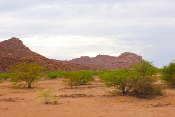
Namibia, located in southwest Africa, is an extraordinary destination with a deep history and culture reflected in its geography and the lives of its inhabitants. This country, one of the most sparsely populated in the world, is home to diverse landscapes ranging from arid deserts to vast savannas and lush forests in the north. Among its natural wonders is the Kalahari Desert, a vast semi-arid region that encompasses parts of Namibia, Botswana, and South Africa.
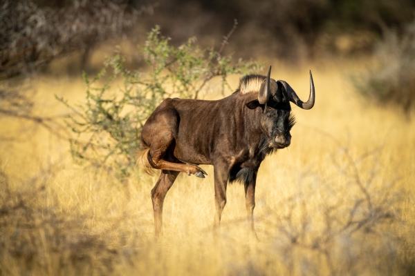
The Kalahari Desert, whose name derives from the Tswana word “Kgala,” meaning “great thirst,” is a unique ecosystem that, despite being called a desert, is actually a dry savanna with a surprising diversity of life. In Namibia, the Kalahari stretches across the east of the country and is home to a rich biodiversity adapted to arid conditions. Species such as the gemsbok antelope, the meerkat, the wild dog, and numerous birds have developed special adaptations to survive in this environment. The vegetation includes acacias and hardy grasses that provide sustenance and shelter for local wildlife.
Namibia’s first inhabitants, the San, or Bushmen, have lived in the Kalahari for over 20,000 years. Their intimate knowledge of the desert has allowed them to develop a hunter-gatherer lifestyle, utilizing ancient tools and techniques. The San are famous for their rock art and unique language, which includes clicking sounds. Their culture and way of life offer invaluable insight into harmonious interaction with nature and human resilience in the face of adversity.
At the end of the 19th century, Namibia was colonized by the German Empire, becoming the colony of German Southwest Africa. During this period, European influence significantly transformed the country. Cities like Swakopmund and Lüderitz still retain German-style architecture, with pastel-colored buildings and typical ornamentation. However, this period was also marked by conflict and tragedy, such as the genocide of the Herero and Nama peoples between 1904 and 1908. This dark chapter is recognized as one of the first genocides of the 20th century and has left a deep mark on Namibia’s collective memory.
After a prolonged struggle for independence, Namibia achieved self-government in 1990. Since then, it has worked to preserve its rich cultural and natural heritage, promoting sustainable tourism and respect for Indigenous communities. The country has implemented conservation programs that involve local populations, especially in areas such as Etosha National Park and the Kalahari Desert, helping to protect endangered species like the black rhinoceros and the cheetah.
Namibia is also a paradise for astronomy lovers. Both the Namib Desert and the Kalahari offer clear night skies free of light pollution, ideal for stargazing. The Kalahari, in particular, is famous for its spectacular views of the Milky Way, providing visitors with an unparalleled celestial experience.
In the Fish River Canyon region, the second largest in the world, you can see geological formations dating back 500 million years. This stunning landscape offers hiking trails that challenge adventurers and reward with unforgettable panoramic views.
The Skeleton Coast, with its mysterious shipwrecks and dense fog, is another of Namibia’s treasures. The San people called it “the land that God made in anger” due to its inhospitable nature. However, this coast is home to abundant marine life, including seal colonies at Cape Cross, where thousands of these animals congregate in a breathtaking natural spectacle.
The capital, Windhoek, located in the heart of Namibia, is a city that combines modernity and tradition. With German and African architectural influences, it offers museums, markets, and restaurants that reflect the country’s cultural diversity. Places like the National Museum of Namibia and the Parliament, known as the “Tintenpalast” or “Ink Palace,” are testaments to its rich history.
En Damaraland, los visitantes pueden encontrar los extraños y antiguos árboles botella y las famosas pinturas rupestres de Twyfelfontein, un sitio declarado Patrimonio de la Humanidad por la UNESCO. Estas pinturas y grabados, realizados por los pueblos San hace miles de años, representan animales, figuras humanas y símbolos abstractos, proporcionando una ventana al pasado prehistórico de la región.
Hardap Reservoir and Game Reserve
The Hardap Reservoir and Game Reserve, located near the town of Mariental in the Hardap Region of Namibia, is a site of great historical, economic, and ecological significance for the country. Built in 1963 on the Fish River, the reservoir is the largest in Namibia, with a storage capacity of approximately 320 million cubic meters of water. Its creation responded to the need to store water in a predominantly arid region, ensuring a supply for agricultural irrigation, human consumption, and fish farming, as well as providing a habitat for wildlife. This project marked a milestone in the country’s water resources management, becoming a central axis for the region’s development.
The reservoir also supports an irrigation system that has transformed agriculture in this part of Namibia. Over the years, it has allowed for the cultivation of crops such as grapes, melons, and various vegetables, fostering the economic development of local communities. Furthermore, it has been key to the development of livestock farming in the region, ensuring a reliable water supply in an area where this activity is essential to the local economy. In this context, Hardap has established itself as an example of how natural resources can be managed to benefit both human communities and the surrounding ecosystems.
RSurrounding the reservoir is the Hardap Game Reserve, which covers approximately 250 square kilometers. This reserve was established to protect the region’s biodiversity and provide a safe haven for animal species that depend on the reservoir’s water. The reserve is home to a variety of wildlife, including mountain zebras, oryx, kudu, giraffes, ostriches, and small antelopes such as the steenbok. It is also known as a birdwatcher’s paradise, with over 200 species recorded, including flamingos, pelicans, cormorants, and ospreys, which take advantage of the reservoir’s abundant fish. The presence of water makes this area a vital refuge during dry seasons, attracting animals from vast distances in search of food.
The Hardap Reservoir and Game Reserve also holds significant cultural and historical value. Before the reservoir’s construction, the area around the Fish River was already known as an important wildlife corridor and a site of human settlement. The region has been inhabited for millennia by Indigenous communities, such as the Nama and San, who adapted their ways of life to the harsh conditions of the surrounding desert. The reservoir’s development transformed this historic relationship with the land, introducing a modern approach to the use of natural resources.
Tourism is another important aspect of the reservoir and reserve. Visitors can enjoy a wide range of activities, including sport fishing, boating, hiking, and safaris. The reservoir is home to fish species such as tilapia, catfish, and Nile perch, making it a popular destination for anglers. Hiking trails and tours in the reserve offer the opportunity to explore unique landscapes and observe wildlife in their natural habitat. Additionally, recreational facilities, such as picnic areas and campsites, make Hardap an ideal place to enjoy nature.
The reservoir’s ecological and economic impact is profound. In addition to its role in agricultural and livestock development and as a source of water for local communities, it also contributes to flood control and aquifer recharge in the region. Although hydroelectric power generation is not a primary function of the reservoir, possibilities in this regard have been explored as a way to further diversify its use.
The Hardap Reservoir and Game Reserve is, in many ways, a symbol of the balance between the need for human development and nature conservation. In a country known for its vastness and aridity, this place stands out as an oasis of life and an example of how infrastructure can effectively integrate with the natural environment. It is a testament to human ingenuity and commitment to sustainability in one of the world’s most challenging landscapes.
Mariental
Mariental, located in the heart of Namibia, is a town that combines a rich history with economic development based on its natural resources. Founded in 1912 as a railway stop between Windhoek and Keetmanshoop, the town owes its name to Maria, wife of Hermann Brandt, the first European settler in the region.
The presence of the Fish River has been both a blessing and a challenge for Mariental. This river, which flows south through the town, has caused significant flooding on several occasions. Before the construction of the Hardap Dam in 1962, notable floods were recorded in 1923 and 1934. Subsequently, despite the dam, the town experienced flooding in 1972, 1974, 1976, 2000, and 2006, the latter being particularly severe due to the opening of the dam’s floodgates following persistent rainfall.
The Hardap Dam, located 22 kilometers northwest of Mariental, is Namibia’s second largest reservoir, with a capacity of 320 million cubic meters and a surface area of 25 km². Built between 1960 and 1963, this infrastructure has been instrumental in supplying water and controlling the flow of the Fish River, as well as boosting agriculture in the region.
Mariental’s economy has adapted to the area’s arid conditions. Livestock farming, especially sheep and ostriches, is predominant. The town once housed an ostrich slaughterhouse that processed meat for export, although it recently closed. Furthermore, thanks to the irrigation provided by the Hardap Dam, citrus fruits and other agricultural products are grown, diversifying the local economy.
Mariental is also known for being home to the oldest congregation of the Dutch Reformed Church in Namibia, founded in 1898. This fact reflects the influence of the Rhenish (German Lutheran) missionaries in the region and their cultural legacy.
En términos de infraestructura, la ciudad está conectada por la línea ferroviaria TransNamib y la carretera nacional B1, lo que facilita el transporte y el comercio entre Windhoek y Keetmanshoop. Esta conectividad ha sido clave para el desarrollo de Mariental como centro administrativo y económico de la región de Hardap.
MMariental is a city that has managed to adapt and thrive despite natural challenges, combining its rich history with sustainable economic development based on agriculture and livestock.
Tropic of Capricorn
In Namibia, the Tropic of Capricorn runs through the south-central part of the country, passing through spectacular desert landscapes. It is one of the most popular tourist attractions due to the signs indicating the exact location of this imaginary line, where visitors often stop to take photographs. Some of these points are located near major roads, such as the C14 connecting Walvis Bay and Solitaire.
The passage of the Tropic of Capricorn through Namibia is particularly remarkable because it crosses the Namib Desert, one of the oldest deserts in the world, estimated to be 55 million years old. In this context, the contrast between the arid desert landscape and the scientific precision of this geographical line creates a unique experience for travelers.
In addition to its geographical significance, the Tropic of Capricorn has astronomical and cultural significance. In the indigenous cultures of southern Africa, solar cycles marked by the tropics influence agricultural and ceremonial traditions. In modern terms, this parallel is a reminder of the climatic and astronomical patterns that determine life in subtropical and desert regions.
The Tropic of Capricorn also crosses other countries in the Southern Hemisphere, such as Botswana, South Africa, Brazil, Australia, and Chile, but the section that crosses Namibia stands out for its accessibility and the unique appeal of its desert environment. It is a must-see for those exploring this country, offering a direct connection to the geographical and astronomical wonders of the Earth.
Kalahari Red Dunes Lodge
Windhoek – Kalahari Route Travel Guide
Now, with mobile apps like Tourist Road Guides, travelers have access to predefined routes and precise recommendations in the palm of their hand. The integration of technologies such as GPS, audio guides, and multimedia content allows for a much more personalized and real-time experience. Users can obtain detailed information on specific points of interest, access historical data and interesting facts as they navigate their destination, all without the need to carry books or rely on outdated information.
This technological transformation allows travelers to explore at their own pace, plan their trip better, and receive content tailored to their interests. In short, technology has breathed new life into the way we travel, making each trip more dynamic and flexible thanks to platforms like Tourist Road Guides.
What Tourist Road Guides offers for your Audio Guide on the Windhoek – Kalahari Route
Tourist Road Guides is a mobile app designed to facilitate travel planning and exploration. It offers predefined routes covering the main points of interest in each destination, integrating an audio guide that provides historical details, interesting facts, and recommendations as the user explores each location. Additionally, the app includes a personalized “What to See” list, highlighting the most relevant points in each location. This structure allows travelers to organize their itinerary efficiently, ensuring they don’t miss any important aspects of the destination.